In the past, when the slowness of transports make also the short travels to last several days, nobody, except the astronomers, could understand that the solar time at the same moment is different from place to place. Indeed, if in a certain place the Sun is at noon position, in a more western place at the same instant of time the Sun has not yet reached the noon position, while the contrary happens for a more eastern place.
If two places are exactly aligned along the north-south direction, they have the same solar time, because they see the Sun forming the same hour angle with the noon position. This alignment, defined geographically as meridian, is given by the half-circle passing for these places and terminating at the terrestrial poles.
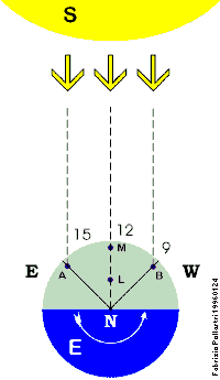
The figure shows an example of those situations. The Earth (E), seen from the north pole (N) direction, is lighted by the Sun (S) with light rays that can be considered parallel for the long Sun-Earth distance. The arrow around the north pole (N) show the versus of the Earth rotation. In the place M it is noon: the Sun is aligned with the direction of the local meridian (MN). In the place A, more eastward, it is 3 PM: the Sun forms an hour angle of +3 hours with the direction of the local meridian (AN). In the place B, more westward, it is 9 AM: the Sun forms an hour angle of -3 hours with the direction of the local meridian (BN). In the place L, it is noon as in the place M: both places are on the same local meridian (LM).
Around the half of 1800, with the coming of faster transport systems and to have an accurate time reference for sea navigation, it was introduced the Greenwich Mean Time (GMT), later called Universal Time (UT). The UT time is measured with astronomical techniques at the Greenwich astronomical observatory in England. The UT time corresponds with good approximation to the mean solar time of the same observatory.
In the meanwhile, in several places in the world, hundreds of different times were adopted, each one corresponding to its own meridian. To simplify this situation, the Earth surface was divided into 24 adjacent, equal and equatorially perpendicular wedges, called time zones, each one delimited by two meridian forming a hour angle of 1 hour at the poles. The mean solar time of the central meridian of each time zone was assigned by convention to all places belonging to the time zone. The Greenwich time zone, centered on the homonymous meridian, was taken as reference time zone. In this way, the time zone right eastward Greenwich is 1 hour in advance in comparison with universal time (UT +01:00), while the time zone right westward Greenwich is 1 hour late (UT -01:00) and so on for all the others. The time zones division was officially adopted on 1884 November 1 at the International Meridian Conference held at Washington D.C. The figure shows the time zones division of the world.
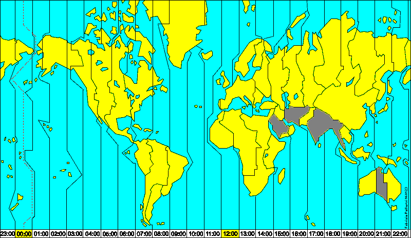
It can be immediately noted that for political and administrative reasons, often the time zones are delimited by state borders instead of meridians. The states with dark color adopt a time different from their time zone. For each time zone it is shown the time when at the Greenwich time zone it is 12:00. In the diametrically opposed time zone, with time 00:00, it is shown the change of date line (dashed line), by convention at the left of this line it is the following day, while at the right it is the preceding day.
Unofficial list
of time zones
The time zone and the possible day-light saving time is
shown for each country. Maintained by the U.S. Naval Observatory.
World
Clock
Simultaneous display of the local time of more than 100
cities in the world. Updates automatically at each minute.
A trip down the Prime (Greenwich) Meridian
From North Pole to South Pole along the Prime Meridian.